Power Line Inspection
Revolutionizing Power Line Inspection
In response to the booming electric grid expansion, SAM has revolutionized power line inspection for existing and new infrastructure. As the industry evolved, so did SAM. Aging infrastructure, reliability, environmental regulations, and cybersecurity are prevalent issues in the market today. Our inspectors are veteran linemen that have invested a career to their passion of power line inspection.
SAM offers a range of inspection types – Visual and comprehensive, Ultra HD – Remote Desktop Inspection, Infrared & Corona, LiDAR, and Ground Inspection often accompanied with UAS close-range data acquisition for distribution lines in sensitive urban environments. It’s not just about finding issues; it’s about a comprehensive assessment.
KEY Technologies
Infrared & Corona
Infrared & Corona
Aerial Comprehensive 8K Video
Aerial Comprehensive 8K Video
Four-Tier Classification System
Four-Tier Classification System
Remote Desktop Inspection
Remote Desk Top Inspection
Power Line Commissioning
Power Line Commissioning
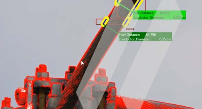
Conductor Measurements to Support Facility Ratings
Conductor Measurements to Support Facility Ratings
Unique, Proprietary AI/ML Offering
SAM has pioneered a field-to-office workflow that supports quick and efficient turnaround of deliverables. With millions of photos collected and sourced for training, SAM has a library of Artificial Intelligence (AI) and Machine Learning (ML) models that greatly improve the quality and speed of remote desktop inspection. Since 2019, SAM has been developing SAM Inspect™. The software exploits cloud architecture to streamline geospatial workflows. SAM’s licensed professionals transform petabytes of complex spatial data into intelligent insights in a holistic Managed Geospatial Services™ framework.
WHY SAM?
SAM has built a reputation as a trusted, knowledgeable, and innovative partner.
Over 1000 data scientists, professionally licensed surveyors, certified photogrammetrists, certified LiDAR specialists, certified thermographers, GIS professionals, and remote sensing analysts comprise the Aerial Mapping & Remote Sensing services.
SAM transforms petabytes of complex spatial data into intelligent insights in a holistic Managed Geospatial Services™ (MGS™) framework. MGS™ is the digital ecosystem that simplifies the complicated so our clients can achieve the impactful outcomes that drive their business forward.
As North America’s premiere MGS™ company, SAM provides practical, precise, and high-fidelity solutions designed to enhance decision-making, mitigate risks, achieve strategic objectives, and drive costs out of our client’s business. Our vision is to advance spatial data acquisition, improve analysis capabilities, and develop predictive analytics to redefine and transform how infrastructure assets are developed and managed throughout their lifecycles.
OUR PEOPLE
SAM’s team of licensed professionals bring trusted experience, knowledge, and innovation to every service engagement.
FEATURED CASE STORY
Get Connected
Join us on this incredible journey to redefine the standards in power line inspection.


